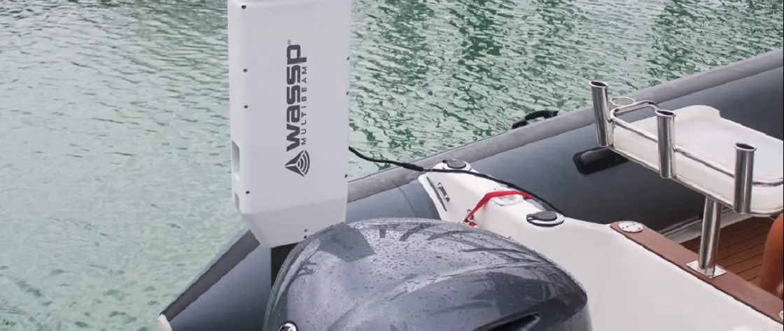
How WASSP W3P Lets Superyacht Tenders Map Seabeds Ahead of the Mothership
By Stephen Yardley · Edited by Stephen Yardley
Image: WASSP Multibeam
A look at WASSP's W3P portable multibeam system and how a superyacht tender can survey a remote anchorage before the mothership enters.
The ability to send a tender ahead of a superyacht to map the seabed can materially change how a remote anchorage is approached. WASSP Multibeam markets its W-Series to expedition yachts for this purpose, with the portable W3P providing a way to gather detailed bathymetric information without permanently installing every survey component on the mothership.
This is a technology explainer rather than a claim that W3P has just been launched. Its relevance is increasing as large yachts travel into areas where official charts may be old, sparse or altered by storms and seabed movement, and where a single downward-looking depth reading is not enough to understand the surrounding terrain.
The tender carries a multibeam sonar and transmits survey information back to the mothership using a wireless link. Bridge personnel can then assess the contours, obstacles and available depth along an intended route or within an anchoring area while the larger vessel remains clear of uncertain water.
The company also supports fixed installations and multiple-tender arrangements, giving crews flexibility according to the equipment and operating programme available. A portable arrangement is particularly relevant when an existing tender is used for expedition reconnaissance rather than commissioning a bespoke survey boat.
A conventional depth sounder records distance beneath its transducer, while multibeam sonar measures across a broad swath and can generate 2D and 3D representations of the seafloor. This makes it easier to recognise a shelf, mound or obstruction outside the precise track already travelled by the tender.
Recorded bathymetry can also build a more detailed local picture for a later return, although crews still need to consider tide, sound-velocity conditions, position quality and changes since the survey. Self-generated mapping is a navigation aid and does not relieve the bridge team of its wider charting and watchkeeping responsibilities.
Detailed bottom shape and depth information can help a captain distinguish between a potentially suitable anchoring area and a location with abrupt changes or hidden hazards. WASSP says its systems are commonly displayed through a PC or integrated with TimeZero Professional, bringing survey output closer to the navigation displays in use aboard the yacht.
For explorer owners, the benefit is not simply access to a new electronic display but greater confidence when deciding whether an unfamiliar location is practical for the vessel's draft and anchoring arrangement. The W3P is a useful example of specialist tender equipment contributing directly to the mothership's operations.
Explore
Go deeper into the yachts, companies, events and destinations directly connected to this article.
Continue reading
The 74m Amels SYNTHESIS is offered for sale through Burgess at €132 million after a 2025–26 Amels yard period that included her five-year special …
Edmiston is offering 40.2m Baglietto PANAM at €27m after her five-year Special Survey, with triple MTU waterjets and a quoted 31-knot top speed.
CRN has delivered the 70m Cerulean, formerly Project Thunderball, after successful sea trials at its Ancona shipyard.

Marine Results International has become a RINA Approved Service Supplier for mast and rigging surveys with no restriction on yacht size or rig type, …
Superyacht Guide
Continue into the wider Superyacht Guide.