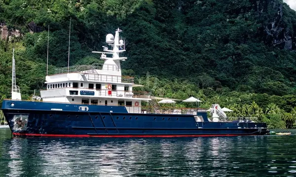
55m Explorer BUCCARA LATITUDE Transits Kiel Canal on Atlantic Passage
The 54.7m BUCCARA LATITUDE has been photographed in Germany’s Kiel Canal while sailing westward, highlighting a 1973 commercial vessel converted into an explorer yacht.

A very strong El Niño is expected to persist into early 2027, changing the background weather risks faced by superyachts. Superyacht Guide examines winds, heat, sea states, rainfall, cyclone patterns and what they mean for routing and seasonal cruising.
El Niño is no longer a distant possibility for yacht operators to watch on seasonal climate charts. By early September 2026 it was firmly established in the tropical Pacific, and the World Meteorological Organization expects the event to strengthen further before peaking towards the end of the year. WMO gives a near-100 per cent probability that El Niño will persist through February 2027, with a very strong event capable of shifting rainfall and temperature patterns far beyond the Pacific.
For superyachts, that does not mean every passage will suddenly become rougher or every Mediterranean anchorage more dangerous. El Niño changes the background climate system rather than dictating individual storms, but it can alter winds, rainfall, tropical-cyclone activity, temperatures and storm tracks. Those changes feed directly into decisions about ocean crossings, seasonal positioning, anchoring, machinery cooling, guest comfort and whether a traditional cruising calendar still carries the margins it once did.
El Niño is the warm phase of the El Niño–Southern Oscillation, or ENSO. It develops when sea-surface temperatures across the central and eastern equatorial Pacific become unusually warm and the normal tropical atmospheric circulation changes with them. The low-level trade winds weaken or reverse in places, ocean heat shifts eastward and the Walker circulation is disrupted.
The important point for a yacht is that these changes do not remain confined to the tropical Pacific. They influence atmospheric circulation over much greater distances, changing where rain falls, where drought develops, how storm tracks behave and how winds change through different levels of the atmosphere. WMO also cautions that a very strong El Niño does not automatically produce equally severe impacts in every region, so seasonal climate signals still have to be translated into regional and route-specific forecasts.
For captains, changes in wind are one of the most immediate ways a climate signal can become an operational issue. El Niño weakens the normal easterly trade winds across parts of the tropical Pacific and changes upper-level winds over both the Pacific and Atlantic. That can alter vertical wind shear, which is especially important for tropical-cyclone development.
This does not create a simple routing rule such as “El Niño means stronger winds”. The effect depends heavily on region, season and the position of other pressure systems. What it does mean is that historical expectations about trade-wind strength, storm tracks and seasonal passages deserve closer scrutiny when a major ENSO event is underway, particularly for yachts undertaking long Pacific repositioning voyages or crossing between the Mediterranean and Caribbean on a tightly planned calendar.
Sea state is produced locally and regionally by wind strength, duration, fetch, currents and distant swell-generating systems, so there is no scientifically useful rule that an El Niño year creates globally higher waves. A yacht can still encounter flat conditions during a strong El Niño and severe seas during an ENSO-neutral year. The operational connection is indirect: if El Niño changes prevailing winds, storm frequency or cyclone tracks, the wave climate changes with them.
More energetic tropical weather in parts of the Pacific can generate long-period swell that travels far beyond the storm itself, while changed storm tracks can make some established passages less comfortable even when local winds at the yacht remain moderate. Captains therefore still need the actual wind, significant wave height, wave period and swell-direction forecast rather than using the words “El Niño” as a substitute for marine meteorology.
El Niño usually adds a temporary warming influence to an already warm global climate, and WMO is warning of increased risks from extreme heat as the 2026 event strengthens. Copernicus reports that western Europe experienced its hottest June–July period on record in 2026, while record-high July sea-surface temperatures affected the Atlantic coast and western Mediterranean and were associated with widespread strong or severe marine heatwaves.
For a superyacht, heat is more than a guest-comfort problem. Higher air and seawater temperatures increase the environment in which air-conditioning, refrigeration, ventilation, machinery cooling and hotel services have to operate, while exterior deck work becomes more physically demanding for crew. Warm nights can reduce recovery from daytime heat, and hotter seawater reduces the temperature difference available to systems that reject heat through seawater cooling circuits.
Perhaps the most counter-intuitive effect concerns tropical cyclones. NOAA’s updated 2026 Atlantic hurricane outlook gives a 75 per cent chance of a below-normal season, with 7–13 named storms, 2–6 hurricanes and 0–2 major hurricanes. NOAA says the strengthening El Niño is expected to increase vertical wind shear across the Atlantic Main Development Region, making it harder for tropical systems to organise and intensify.
For Caribbean-based superyachts that may sound reassuring, but a below-normal season is not a safe season. Seasonal outlooks do not predict individual landfalls and a single storm can still cause catastrophic impacts. Hurricane plans, insurance conditions, marina evacuation rules and conservative routing therefore remain necessary even when basin-wide activity is suppressed.
The Pacific can experience the opposite tendency. NOAA’s eastern Pacific outlook says El Niño conditions are likely to support higher levels of activity there, while strong El Niño conditions are typically associated with dramatically elevated activity in the central Pacific. A yacht planning Mexico, Central America, French Polynesia or another Pacific programme therefore faces a different seasonal risk profile from one spending winter in the Caribbean.
El Niño can substantially redistribute rainfall, increasing flood risk in some regions while increasing drought and wildfire risk in others. Those changes matter to yachts even when the vessel itself is offshore because floods, landslides, wildfire, damaged infrastructure and port disruption can affect an itinerary before sea conditions become unsafe. A destination can remain navigable by sea while becoming operationally difficult ashore.
For Europe and the Mediterranean, the relationship is less direct and forecast confidence is lower than in the tropical Pacific. It would therefore be wrong to attribute every Mediterranean thunderstorm, waterspout, heatwave or episode of violent wind directly to El Niño. The practical response is to use ENSO as background intelligence while continuing to rely on short-range forecasts, radar, satellite data, local warnings and professional weather-routing judgement for individual passages and anchorages.
The Mediterranean yacht season is concentrated into July and August because owners, charter clients and families traditionally have time to travel, not necessarily because those two months always provide the best combination of temperature, sea state, crowding and operational comfort. If peak summer increasingly combines extreme heat, marine heatwaves, crowded anchorages and episodes of violent convective weather, May, June, September and parts of October can become more attractive in some regions.
A similar argument applies to transoceanic positioning. A strengthening El Niño can make the Pacific cyclone picture more important while reducing average Atlantic hurricane activity, but the correct departure date still depends on the forecast that actually exists when the yacht is ready to move. Seasonal probabilities can tell a captain where risk may be tilting; they cannot tell the bridge team whether next Tuesday is safe.
The strongest operational response is not to create a separate binder labelled “El Niño”. It is to give the yacht more margin in the systems already used to manage weather: earlier seasonal planning, professional routing, realistic fuel reserves, flexible berthing, machinery prepared for high ambient and seawater temperatures, conservative anchoring decisions and enough schedule freedom for the captain to delay or divert.
El Niño matters to superyachts because large yachts can operate across several climate zones in a single year. A vessel may finish a Mediterranean summer, cross the Atlantic, spend winter in the Caribbean and then reposition through the Panama Canal or Pacific, exposing the same yacht to very different manifestations of the same global climate event. The question is therefore not whether El Niño will “hit” superyachts, but whether its influence on winds, heat, rainfall, cyclones and the wider weather pattern changes the margins on which the cruising programme was built.
Continue reading
The 54.7m BUCCARA LATITUDE has been photographed in Germany’s Kiel Canal while sailing westward, highlighting a 1973 commercial vessel converted into an explorer yacht.
The S-100 navigation transition is not just a chart-data upgrade: Teledyne Raymarine Commercial says bridge teams and shore managers must plan workflows, training and …
Can a Superyacht Transit the Suez Canal? Fees, Security and Planning Yes. Tourist yachts can transit the Suez Canal, with current Suez Canal Authority …
Can a Superyacht Transit the Panama Canal? Cost, Size and Booking Yes. Superyachts transit the Panama Canal, but tolls, booking options, pilotage and scheduling …
Superyacht Guide
Continue into the wider Superyacht Guide.
Business opportunities · Superyacht Guide
Companies serving the superyacht market can discuss clearly identified advertising, sponsorship and business-profile opportunities. Commercial activity remains separate from independent editorial coverage.